Monday, January 10, 2011

West African Empires


Today we will begin an examination of three African empires -- Ghana, Mali and Songhai. Although none of these is as famous as Ancient Egypt, each is incredibly important in the history of African trade with the rest of the world.

To start with, take out a sheet of loose leaf paper. You will need it to complete today's classwork.

Part 1: Landforms in West and North Africa
  1. Open your book to a physical map of Africa.
  2. Focus on West and North Africa. List as many landforms and waterways as possible in the time provided.
  3. Many major historical African cities, such as Alexandria, Cairo, Tunis and Carthage, were located along the northern waterways. Others were located along the west coast, near the Atlantic Ocean.
  4. Starting around 700 CE, North Africa from Egypt to Morocco was conquered by Arab-Muslim invaders from the Middle East.
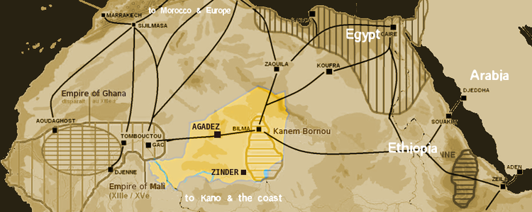
  5. Over time, these newcomers began to send traders on camelback across the Sahara to West Africa.
  6. Answer the following question: What would motivate a person to travel across an enormous desert?
Part 2: Researching West Africa's Past
You will be assigned one of three historic West African trade empires to research.
  • Ghana
  • Mali
  • Songhai
Answer each of the following questions on the sheet of loose leaf using the sites provided. Be sure to answer in complete sentences. For each question, write down the website you used to find your information. This should look like a link. You might use the same website for multiple questions. The assignment is worth a total of 20 points. It is due on your desk at the start of tomorrow's class period.
  1. Record the name of your empire and its relative location. State which modern countries it would be located in.
  2. Record the dates during which your empire was powerful.
  3. Record the resources it traded to North Africa/the Middle East.
  4. Record the resources it received in return from North Africa/the Middle East.
  5. Name any important rulers and describe their importance.
  6. Describe how contact with outside traders influenced the country.
  7. Explain how these influences were (or were not) assimilated into your empire's culture.
  8. Describe the ways in which your empire changed after coming into contact with other cultures.
  9. Name and describe any art, music and artifacts your empire is famous for.
  10. Explain why your empire ultimately declined and fell.
Websites for Research
Historic Maps:
Trade Routes Between Middle East and North Africa:
Ghana, Mali and Songhai Empires:

Monday, 1/10/2011 Homework

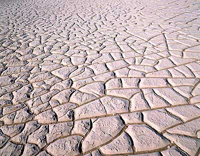
Use the information on pp. 424-425 to complete the following on the back of your Desertification Cause and Effect T-Chart. The assignment is worth 3 points per square, and 12 points total. It is due on your desk at the start of tomorrow's class period.
Divide the paper into four equal squares.
Use each square to draw and describe the following four steps which lead an area of land toward desertification.
Loss of rainfall
Overuse
Death of soil-conserving plants
Near total loss of water

Friday, January 7, 2011

Friday, 1/7/2011 Homework

This weekend, read chapter 18.3 and take Cornell Notes. The notes are due on your desk at the start of Monday's class. They are worth 10 points.

In addition, if you did not finish your Sahara Desert story from class, complete this as well. The guidelines I showed you in class are below:
Read the information on pp. 420-421.
Then, imagine you have to cross the Sahara desert. Write a short story about your journey.
Include challenges you would face, sights you would see, the mode of transportation you would take, and other information.
All info. must be from the book unless otherwise cleared by me.

10 points. Be prepared to share with class.

Thursday, January 6, 2011

Africa's Global Connections

Today we will continue to develop two themes of our Africa unit -- Diversity and Globalization.

In order to do this, we will look at African history and create a timeline. In addition, we will take a look at some modern news events happening in Africa.

First, note that the following abbreviations are used throughout the activity:
  • BCE "Before the Common Era" (sometimes also called BC)
  • CE "Common Era" (sometimes also called AD)
We will again be looking at maps provided by Michigan State University. Instead of pictures, these maps include historical data. This is meant to provide you with a general background of Africa's history. Next week, we will start to get into more specifics. You will complete today's assignments on loose leaf paper.

Map 1: Ancient African History to the 1400s (10 points)
Click on the following link and listen for instructions:
http://exploringafrica.matrix.msu.edu/teachers/curriculum/m4/activity1.php

The map shows the location of historical events. By clicking on each of the numbers, you can pull up information on what happened, where it happened, and when it happened.
  1. You will first use the information on the map to create a timeline as described on the site (5 points).
  2. Then, you will create a graphic organizer showing historic connections between Africa and the rest of the world (following the site's example) (5 points).
Map 2: African History from the 1400s to the 1800s (10 points)
Click on the following link and wait for instructions:
http://exploringafrica.matrix.msu.edu/students/curriculum/m4/activity2.php
  1. Again, use the information on the map to create a timeline as described on the site (5 points).
  2. Then, create a graphic organizer showing historic connections between Africa and the rest of the world (following the site's example) (5 points).
Homework: Study for QUIZ!

Wednesday, January 5, 2011

Online Study Resources for the Map of Africa

In order to study for Friday's map quiz, visit the following site:

http://www.ilike2learn.com/ilike2learn/africa.html

Wednesday, 1/5/2011 Homework: Resources in Africa

Examine the maps on p. 419 and p. 405. Use them to answer the following questions:
1.List FIVE countries that produce petroleum.
2.List THREE countries where commercial farming is a major economic activity.
3.List THREE countries in southern Africa that produce diamonds.
4.Identify TWO countries where livestock is an important commodity.
5.List the countries that include manufacturing and trade centers.
6.Fish is an important food in a number of African countries. Identify FIVE countries where fish is an important food resource.
7.List FIVE countries where you might find gold, platinum or other precious metals.
8.List FIVE countries which appear to exist mostly at the FOLK level of society (based on the information given on the map).

Monday, January 3, 2011

A Brief African Odyssey

Today, you will go on a journey across Africa using resources provided by Michigan State University. The links and questions below are designed to give you an overview of the continent's diverse cultural characteristics and physical features.

This activity is a series of maps of Africa studded with thumbnail pictures. If you click on a picture, a larger version of it will pop up. The pictures express a particular theme for that page, including: geography, culture, religion, making a living, transportation, and where people live.

You will complete this assignment in an e-mail to me. It is due at the end of today's class period. The assignment is worth a total of 20 points, with points deducted for grammar, completeness and accuracy of responses.

Map 1: Physical Geography
Click on the following link:
http://exploringafrica.matrix.msu.edu/students/curriculum/m3/activity1.php

Then, do the following for each picture:
  1. Briefly describe the photo.
  2. Name the landforms present in the photo.
  3. Describe the climate shown in the photo.
  4. Describe the vegetation visible in the photo.
When you've done this for each photo, imagine that you were really going on a vacation to Africa. How would what you see in these photos affect your packing?

Map 2: Culture
Click on the following link:
http://exploringafrica.matrix.msu.edu/students/curriculum/m3/activity2.php

Then, answer the following:
  1. What types of music, art and culture do you see in the photos?
  2. Does anything remind you of something similar you've seen in the U.S.? Explain.
Map 3: Religion
Click on the following link:
http://exploringafrica.matrix.msu.edu/students/curriculum/m3/activity3.php

Then, answer the following, including references to specific photo numbers when appropriate:
  1. What are the different types of religious buildings you see in these pictures? Do you recognize any of them?
  2. Can you definitively associate any religion with any of the buildings?
  3. Do any of them look like anything you are familiar with in Chicago? Explain.
Map 4: Making a Living in Africa
Click on the following link:
http://exploringafrica.matrix.msu.edu/students/curriculum/m3/activity4.php

Then, answer the following:
  1. What jobs are shown in the photos?
  2. What can the location of these jobs tell you about the area? (HINT: think about climate, vegetation, landforms and natural resources)
  3. Could you find employment in any of the industries shown in Chicago? If not, give an example of a place in the United States where a person might be able to find the type of job(s) shown.
Map 5: Transportation in Africa
Click on the following link:
http://exploringafrica.matrix.msu.edu/students/curriculum/m3/activity5.php

Then, do the following for each photo:
  1. Describe the photo. Include the region in Africa in which the photo is located (using compass directions) and specific information about the environment shown.
  2. Describe the type of transportation shown. Explain what this might tell you about the people living in the region.
Homework:
For tonight, read Chapter 18, Section 1 in your textbook (pp. 414-418). Take Cornell Notes on the section in your notebooks. If you need a refresher on the Cornell Note taking system, take a look at this link from Cornell University.

The notes are worth 10 points, and are due on your desk at the start of tomorrow's class period.